
It was weird during my forced hiatus from blogging (due to lack of internet availability) - I kept a journal to remember my journeys but the writing style changed dramatically. I've had trouble getting this started but I guess I just need to bite the bullet and start with the series that I talked about earlier. (Oh! Also, I've decided to move to Bozeman, MT for the winter with a group of friends - so I'll have a kitchen again!!)
This first photo is from Dunraven Pass, which is the road in between Canyon (my home) and Roosevelt Lodge. It's one of the most scenic drives in the park - it goes up through the mountains and winds back down through a valley before being dropped out near Lamar Valley. This was taken very early in the season and has become one of my favorite pictures out here - I just love the blueness of the sky overlooking the ridges of the snow covered mountain. It makes me feel at peace with the world.

My home is Canyon Village. It's about a mile or so north of the Grand Canyon of the Yellowstone. I often walk down to the Canyon and sit contemplating when I just need some time to myself. The area called Inspiration Point, has a board with info and this quote: "I thought how utterly impossible it would be to describe to another the sensations inspired by such a presence. As I took in this scene, I realized my own littleness, my helplessness, my dread exposure to destruction, my inability to cope or even comprehend the mighty architecture of nature." - Nathaniel P. Langford, 1870

Just to the south of the Canyon is Hayden Valley. It's well-known for viewing wildlife and wildflowers. The bison's rut season in Hayden Valley just ended, which is when they are fighting for the female's attention. The valley contains geothermal features as well since it is right in the middle of the caldera. (The caldera is the top of the volcano that Yellowstone is situated right on top of.) One time I went on a hike through Hayden Valley (not on a trail) and we ran into a mini-geyser basin where I saw a wolf! This is on the Wapiti Lake trail during the height of the wildflower season.

I didn't go all the way to the Wapiti Lake, which is about 20 miles out from the trail head, but instead turned in at the Silver Chord Cascade drop and went back towards Lily Pad Lake. Lily Pad Lake is covered with wild water Lilies that have yellow flowers. My old roommate once informed that water lilies are an endangered species so it makes me glad whenever I see them growing in their natural habitat.

The Silver Chord Cascade Overlook (on the opposite side of the canyon) is one of my favorite places to go and sit. It's only about a mile or so into the Seven Mile Hole trailhead and not often traveled. You can hear the roar of the river below you and I often run into not often seen animals (such as a short-tailed weasel!).

I'd been wanting to get up super early in the morning and walk down to the Canyon to see the sunrise, which I did one morning (and will have to re-attempt) that ended up being mega foggy. It added a neat affect to the forest - kind of made it feel forbodding.

However, once the sun came out and started burning the fog away the light was able to shine through the trees. It was really beautiful in the forest.

One popular hike to do just north of us is Cascade Lake. It has pretty good fly fishing on the lake and is a really beautiful area. On my only fishing trip attempt, we headed out there (after a few beers) and forgot the reel for one of the rods and the other rod was too tangled! We had a good time just sitting out on the edge of the lake though.

I talked about the time early on in the season when Adam and I hiked out to Cascade on a rainy afternoon. The double rainbow appeared behind us while a sepia colored mountain was in front of us. (I have seen more rainbows this summer than I have seen my whole life - they are so magically beautiful!)

There is a mountain on the side of Cascade Lake that you can climb up for an additional three miles. It gives you a great overview of the area - the big lake is Cascade and the smaller one just to the west is Grebe Lake. Off in the distance, you can see Hayden Valley (only a sliver of it is really visible of the far east). The clouds were covering us like a blanket this day, but thankfully it didn't rain or hail on us!

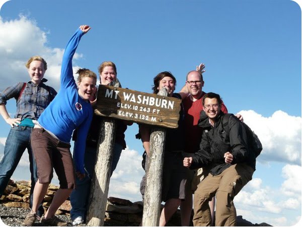
We hiked Mount Washburn, which is Dunraven Pass and is the northern point of the Caldera. It was soo incredibly windy that I didn't even have a desire to pull out my camera. However, from the top you could see the Beartooth Mountains, Lake Yellowstone, the Tetons, Electric Peak - pretty much anywhere in the Greater Yellowstone Area. We did get this group shot taken after multiple tries of the camera being blown over from the wind.
Further north (almost to Roosevelt Lodge) is a geological feature that I really don't know very much about. These ridges just pop out of the mountain sides and create the designs.

Just past Roosevelt Lodge is Lamar Valley, which beings with Slough Creek. The Slough Wolf Pack lives on top of this rocky ridge; however, they are too far away that you can't see them without power scopes. (Although, it's worth it to stop - there are so many people out here with their scopes and are usually kind enough to share.) The sun and clouds were creating beautiul shadows and colors.

My mom and brother (and possibly my dad) will be here in a couple weeks. I'm super jazzed to share Yellowstone with them!


Welcome back.
ReplyDeleteStunning photographs. Thank you so much for sharing.
Seeing many rainbows, oh you must have felt really blessed. I'm like a child every time I see one I'm lost in total admiration. A double rainbow must be even more glorious.
Thanks for noticing that I am back! I've been having a blast of a summer - and still so much more to share.
ReplyDelete